lot, vacant land, for sale, Candelaria, Naranjo, Alajuela
Candelaria, Naranjo, Naranjo, Alajuela, Costa Rica
Overview
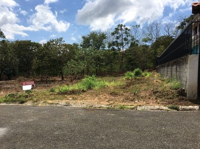
• from Maxipali at Naranjo, in 141 Road, 1.2 Km NorthWest through old 148 Road • WAZE 10.107758, -84.393270 • 440 m2 • 14 m width • 33 m depth • Altitude 1,111 m.s.n.m. •
- Price
- $38,000
- Listing ID
- LL2100061
- Property Type
- Home Construction Site
- Listing Type
- Land Listing
- Status
- Active
- Images
- 7
- Location Type
- Mountain
- View Type
- Mountain View
- Total Lot Size
- 440.00 m² (4,736.10 sq ft)
Description
• ₡23,500,000 •
• from Maxipali Naranjo in Route 141, 1.2 Km NW through old Route 148 •
• coordinates for Waze and Google Maps 10.107758, -84.393270 •
• 440 m2 lot size • front 14 m • depth 33 m • altitude 1,111 msnm •
• 3 Km. to Radial Naranjo and downtown Naranjo •
• 5 Km. to Bernardo Soto Highway •
• plano visado (cadastral plan authorized for constuction
• in quiet dead end street •
• Provincia Alajuela • Cantón and District Naranjo •
• zipcode 20601 • located at Candelaria •
Details
- Total Lot Size
- 440.00 m² (4,736.10 sq ft)
- Location
- Candelaria, Naranjo, Naranjo, Alajuela, Costa Rica
- Country
- Costa Rica
- State
- Alajuela
- County
- Naranjo
- District
- Naranjo
- City/Town
- Candelaria
- Zip Code
- 20601
- Location Type
- Mountain
- Geographic Type
- Dry Forest
- View Type
- Mountain View
- Elevation
- 1,110.00 m (3,641.73 ft)
- Street Access Type
- Paved Road
- Type of Water
- City Water
- Type of Sewer
- Septic
- Type of Internet
- Cable Internet
- Type of Television
- Cable Television
- Type of Electricity
- Public
- Telephone Available
- Yes
- Price per Square Meter
- $86.36/m2 ($8.02/sqft)
- List Price
- $38,000
- Ownership Type
- Personal
Pictures


Map
Disclaimer
Information regarding this property has been provided by its owner and/or the owner's agent. Propertyshelf Ltda verifies basic listing data but will not be held responsible for the information contained herein. For more information on ownership risk, please see the legal description. When purchasing property, clients are advised to consult with their own attorney.